SOP Reference: MWS-M01-L3
Lesson 3: Site Selection & Buffer Zones
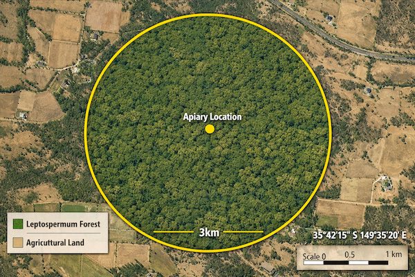
Establishing the 3km clinical radius and GPS validation protocols
The 3km Rule: Scientific Foundation
Honeybee foraging range studies using harmonic radar tracking and pollen DNA analysis demonstrate that worker bees typically forage within a 3-kilometer radius of their hive under optimal conditions. While individual scouts may venture up to 5 kilometers when resources are scarce, the majority of nectar and pollen collection occurs within this tighter boundary.
For pharmaceutical honey production, the 3km radius represents the mandatory exclusion zone within which all land use, vegetation management, and chemical applications must meet clinical standards. Any contamination source within this zone poses direct risk to honey purity through bee transport of residues, volatiles, or particulate matter.
This exclusion radius is not negotiable. Sites failing to meet 3km criteria cannot produce pharmaceutical-grade honey regardless of all other compliance measures.
Site Selection Criteria
Primary Requirements
Candidate sites undergo multi-phase evaluation before approval for clinical honey production. Initial desktop assessment reviews satellite imagery, land registry records, and agricultural activity databases to identify potential contamination sources. Sites proceed to field validation only after passing desktop screening.
Mandatory Exclusions Within 3km Radius
| Land Use | Exclusion Rationale | Detection Method |
|---|---|---|
| Conventional Agriculture | Pesticide drift, herbicide application | County agricultural records, aerial imaging |
| Golf Courses | High pesticide use, fertilizer runoff | Satellite imagery, municipal databases |
| Industrial Facilities | Air emissions, chemical storage | EPA facility registry, emissions reports |
| Highways & Major Roads | Herbicide right-of-way maintenance | Transportation department records |
| Waste Management Sites | Leachate contamination, air quality | EPA Superfund database, state records |
| Utility Corridors | Vegetation control chemicals | Utility company maintenance records |
Optimal Site Characteristics
- Elevation: Between 300-800 meters above sea level provides optimal temperature regulation and reduced frost risk
- Slope: Gentle south-facing slope (5-15 degrees) maximizes solar exposure and promotes air drainage
- Wind Protection: Natural windbreaks or topographical shelter reduces colony stress without restricting air circulation
- Water Drainage: Well-drained soil prevents standing water and reduces fungal disease pressure
- Access: All-weather road access for equipment and harvest operations without traversing contaminated areas
- Security: Natural barriers or fencing capability to prevent unauthorized access and vandalism
GPS Mapping and Documentation
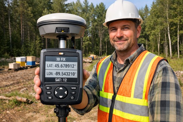
Establishing Coordinates
Professional-grade GPS receivers with sub-meter accuracy establish the precise geographic coordinates of the apiary center point. Consumer-grade smartphone GPS lacks sufficient precision for regulatory documentation. Survey-grade equipment using real-time kinematic (RTK) correction achieves centimeter-level accuracy.
The recorded coordinates use the WGS84 datum in decimal degree format to six decimal places. This precision represents approximately 10-centimeter accuracy at the equator and tighter tolerance at higher latitudes.
Boundary Verification Protocol
- Center Point Establishment: GPS receiver operates for minimum 10 minutes at the planned hive placement location, averaging position readings to compensate for atmospheric interference
- 3km Circle Generation: GIS software generates a perfect 3km radius circle using the averaged center coordinates as origin
- Overlay Analysis: The 3km circle overlays onto current satellite imagery, topographical maps, and land use databases
- Ground Truthing: Physical site inspection walks the perimeter at 8 cardinal points to verify no undocumented contamination sources exist
- Photographic Documentation: Geotagged photographs capture the view from center point toward each cardinal direction
- Annual Re-verification: GPS coordinates and boundary conditions undergo annual re-survey to detect land use changes
Land Use History Assessment
Historical Contamination Investigation
Current land use represents only part of the contamination risk profile. Persistent organic pollutants, heavy metals, and petroleum hydrocarbons from historical industrial operations remain in soil decades after facility closure. Sites with documented contamination history require extended testing before consideration for pharmaceutical apiary use.
Investigation Sources
- County property records and historical plat maps
- State environmental department databases
- EPA Superfund and brownfield site registries
- Historical aerial photographs from county archives
- Agricultural extension service records of past crop types
- Department of Transportation herbicide application logs
- Interviews with long-term local residents
Red Flag Indicators
| Historical Use | Persistent Contamination Risk | Investigation Required |
|---|---|---|
| Former Agricultural Land | Arsenical pesticides, DDT, chlordane | Soil testing to 60cm depth |
| Industrial Sites | Heavy metals, petroleum hydrocarbons | Phase II environmental assessment |
| Railroad Corridors | Creosote, coal tar, lead paint | Soil and vegetation sampling |
| Former Orchards | Lead arsenate, mercury compounds | Extended soil testing program |
Neighbor Relations and Land Use Agreements
Securing the Buffer Zone
Unless the clinical apiary operator owns or controls all land within the 3km radius, formal agreements with neighboring landowners become necessary to prevent future contamination events. Verbal assurances lack legal enforceability and provide no protection against property sale or tenant change.
Conservation Easements
The gold standard for buffer zone protection involves conservation easements that legally restrict future land use. These permanent or long-term agreements record with property deeds and bind future owners. Easement terms prohibit pesticide application, industrial development, and other activities incompatible with pharmaceutical honey production.
Easements typically involve one-time compensation to landowners for accepting use restrictions. While expensive, they provide permanent protection against buffer zone compromise.
Right-of-First-Refusal Agreements
When conservation easements are economically infeasible, right-of-first-refusal agreements provide secondary protection. These contracts grant the apiary operator the option to purchase adjacent properties before they go to market, preventing acquisition by incompatible users.
Annual Use Verification
Even with legal protections, annual verification confirms no unauthorized activities have occurred within the buffer zone. This surveillance includes seasonal aerial imagery review, boundary inspections, and communication with neighboring landowners to monitor any planned changes.
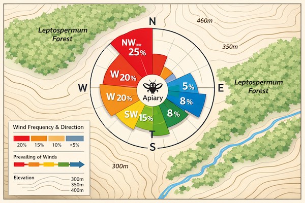
Climate and Microclimate Factors
Temperature Patterns
Pharmaceutical honey production requires consistent temperature patterns that support year-round colony health without extreme stress events. Sites with winter minimum temperatures below negative 15 degrees Celsius demand specialized winterization that increases contamination risk through additional equipment and materials.
Summer maximum temperatures exceeding 40 degrees Celsius stress colonies and increase water consumption, potentially drawing bees to contaminated water sources outside controlled areas.
Precipitation and Humidity
Annual precipitation between 1000-2000mm provides adequate natural water without creating persistently high humidity that promotes hive mold and fermentation. Regions with distinct wet and dry seasons concentrate honey production into predictable windows aligned with Leptospermum bloom periods.
Wind Patterns
Prevailing wind analysis identifies potential drift contamination pathways. Sites positioned downwind from agricultural areas face higher exposure risk even when those areas fall outside the 3km radius. Wind rose data from nearby weather stations informs site orientation and windbreak placement.
Soil and Groundwater Testing
Baseline Contamination Assessment
Before apiary establishment, comprehensive soil and groundwater testing establishes baseline conditions. This testing serves multiple purposes: verifying absence of existing contamination, providing comparison data for future monitoring, and meeting regulatory documentation requirements.
Soil Sampling Protocol
- Sample Grid: Minimum 9 sample points arranged in 3x3 grid covering proposed apiary footprint plus 50-meter perimeter
- Depth Profile: Samples collected at 0-15cm (topsoil), 15-30cm (subsoil), and 30-60cm (deep soil) at each point
- Composite Samples: Depth-matched samples combine into depth-specific composites for laboratory analysis
- Chain of Custody: All samples maintain documented custody from field collection through laboratory analysis
Analytical Testing Panels
| Test Category | Target Analytes | Action Level |
|---|---|---|
| Heavy Metals | As, Pb, Cd, Cr, Hg, Cu | Background reference values |
| Pesticides | 400+ compound screen | Non-detect for all compounds |
| Petroleum Hydrocarbons | Total petroleum hydrocarbons | Below 10 ppm |
| PCBs | Polychlorinated biphenyls | Non-detect |
| Dioxins | TCDD and congeners | Below WHO TEQ limits |
Documentation and Regulatory Approval
Site Qualification Package
The complete site qualification documentation assembles into a comprehensive package submitted for regulatory review. This package forms part of the permanent record for pharmaceutical honey lots produced from the site.
Required Documentation Components
- GPS coordinates with accuracy certification
- 3km radius map with satellite imagery overlay
- Land use survey results for entire buffer zone
- Historical contamination investigation summary
- Soil and groundwater testing results
- Neighbor agreement documentation
- Climate and microclimate data analysis
- Photographic documentation (minimum 16 images)
- Site access and security plan
- Emergency response and contamination mitigation protocols
Annual Re-Qualification
Site approval is not permanent. Annual re-qualification confirms no changes have occurred that compromise buffer zone integrity. This includes updated satellite imagery review, neighbor verification, and targeted testing if concerns arise.
Critical Takeaways
- 3km exclusion radius is mandatory and non-negotiable for pharmaceutical production
- GPS coordinates must use survey-grade equipment with sub-meter accuracy
- Historical land use investigation identifies persistent contamination risks
- Conservation easements provide strongest legal protection for buffer zones
- Soil testing at multiple depths establishes contamination baseline
- Annual re-qualification confirms ongoing site suitability